

1448
The history of Siedlce goes back over 470 years. The first mention of the city comes from 1448. The area, where Siedlce is currently located, was one of the northernmost part of the Małopolska region of Łuków and together with it belonged to the Sandomierz province, and from 1474 to Lublin province.
This state of territorial belonging remained until the Third Partition of Poland. Thus, the northernmost part of the Łuków land bordered from the west along the Muchawka River with the Czersk and Livonian lands. From the north and east Liwiec river was the border with Podlasie.
This little accessible corner at the fork of the Muchawka and Liwiec rivers was located away from the main communication routes. In the Middle Ages, the "Podlaski" trail, leading from Gdańsk through Łomża, Węgrów, Drohiczyn to Łuków and further to Lublin, as well as "Warszawski" connecting Warsaw with Lithuania and leading through Stanisławów, Liw, Węgrów, Sokołów, Wysokie, Drohiczyn and Brest, originally bypassed Siedlce from the north.
XVth century
In the mid-15th century a road leading from Węgrów through Chodów, Siedlce and further to Łuków was established, as a result of which the "Podlaski" trail was changed. At the end of the 17th century, the road from Warsaw to Brest via Siedlce became more and more important. In the second half of the 18th century it was already the main route, while the former "Warsaw" route was of secondary importance.
Four factors had the most important impact on the spatial shape of contemporary Siedlce: the creation of the village of Siedlce, the location of the city under Magdeburg Law in 1547 by King Sigismund I the Old, establishment of a magnate residence and incorporation of the surrounding villages or their parts into the administrative borders of the city (Piaski Zamiejskie, Piaski Starowiejskie , Roskosz, part of the Starawieś majorate and part of the Golice majorate).
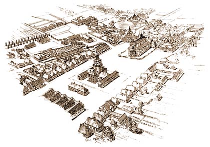
The spatial arrangement of the Siedlce village was finally formed in the second half of the 15th century, giving rise to the development of larger settlement units. In the first half of the 16th century, the village's spatial arrangement consists of two independent elements: the village of old origin and the new village founded in 1503 by Daniel Siedlecki called "Nova Siedlcza", connected with the first church built between them in 1530. The city was erected with a location document based on Magdeburg Law, issued by King Sigismund I the Old on January 15, 1547. This fact was the most important factor in the city's spatial development. It caused the transformation of a dispersed and not very closely related settlement complex into a homogeneous spatial arrangement, starting from its center.
Urban planning of the newly created city, consisted of three parts:
• the city,
• a court complex
• and Stara Wieś (Old Village).
The spatial structure of Siedlce from the end of the 18th century is already characterized by transparency, regularity and unity of architectural composition which indicates a planned reconstruction of the city. These changes occurred in several stages, with two of them have appeared to be the most important. The first change relates to Kazimierz Czartoryski and the second one to the activities of hetmans' wife Aleksandra Ogińska. The scope of their reconstruction work was enormous and contributed to the total urban and architectural change in Siedlec, especially under the power of Aleksandra Ogińska.
However, the spatial arrangement of the city center was tidied up by K. Czartoryski, on the occasion of a fire that destroyed part of the city in 1692. It marked out a new shape of the market and adjacent streets. This arrangement allowed for the further planned expansion of the center and its outskirts in the 18th century. The exceptional significance of A. Ogińska is primarily due to her investment activity in the palace complex, consisting in its thorough transformation. The palace area was enlarged northwards by a park and a sentimental garden.
XIXth century
The nineteenth century was a period of dynamic development of the city. It contributed to the city's functioning as the administrative center. Siedlce was the seat of the circular authorities - Kreisamt (1795-1809) in the Austrian Partition, the capital of the department (1810-1815) in the Duchy of Warsaw, the capital of the Podlasie Province (1815-1837) and twice the seat of the governorate authorities (1837-1844 and 1867-1912) , poviat (1844-1866 and 1913-1915) in the Russian partition and the seat of the poviat authorities - Kreisamt (1915-1918) in the General Government of Warsaw during the first German occupation. The location of the crossroads was another important factor influencing the development of Siedlce. The city's significance increased due to the Warsaw-Brest road (1818-1820) and the construction of railway lines connecting Siedlce with Warsaw (1866), Brest (1867), Małkinia (1887) and Czeremcha (1906).
The second half of the 19th century was a period of the dynamic population growth. 50% of the total population of Siedlce were Jews with trade and craft in their hands. A significant percentage were Russians - mainly officials of the tsarist administration. Until the mid-nineteenth century, Siedlce developed essentially as part of the spatial arrangement that was created by the end of the eighteenth century, the increase of population caused the density of buildings and its transformation from one-story to two-story and three-story ones. The spatial arrangement of the western part of the city was thoroughly changed due to the Brest route marked out by Różniecki Street (currently J. Piłsudski Street), the construction of the prison and the establishment of fiscal (urban) embankments around the city. The introduction of embankments limited the spatial development of Siedlce for about 50 years. Construction movement initiated after 1840 was interrupted by a fire of the city in 1854, which destroyed about 45% of the city's buildings.
In the second half of the nineteenth century, the expansion of the city was directed to the south in connection with the railway carried out in 1866-1867 and another fire in 1865 which consumed more than 100 houses in the city center. It caused the development of a new regulation of the city plan and connection of the planned railway station with the city. The new district was connected to the downtown with Alejowa Street (currently J. Kilińskiego Street) which harmoniously connected both parts of the city.
The city of Siedlce, from the granting of municipal rights in 1547 to 1807, was privately owned initially by the Gniewosz Siedlecki family, in the first half of the 17th century it was the property of the Olędzki family, and from the second half of that century to the beginning of the 19th century it became the property of the Czartoryski family and related to them the Ogiński family. After the death of A. Ogińska in 1798, the Siedlce estate, by inheritance, fell to the Czartoryski family who in 1807 exchanged it with the Austrian government for state goods in the Lublin region. Since then, the city has ceased to be private property.
At the turn of the 19th and 20th centuries, the city expanded its borders primarily to the west. It was associated with the dynamic urban and economic development of the city. The rapid development of the suburbs facilitated the efforts of the city authorities to connect them to administrative borders.
1907
In 1907, the area of the city was significantly expanded to include the suburbs: Old Private Village, Poduchówka, Aleksandrówek Colony, Stara Wieś Majorate and the court of Napoleon Jasiński.
On the eve of the outbreak of World War I, Siedlce had over 30,000 inhabitants. The city's development was interrupted by the outbreak of World War I.
In the years of the Second Republic of Poland, Siedlce was a poviat city in the Lubelskie Voivodeship and a seat of poviat and city authorities. The city, located in the northern part of the Lublin Province, on important communication routes from west to east and from north to south, had a good connection with Warsaw, Brest, Bialystok, Sokołów Podlaski, Węgrów, Łuków, Lublin, and Garwolin.
In the interwar years, Siedlce became an important communication, administrative, commercial, artisanal, and cultural node, and also the largest labor market in Podlasie. The city was also the important educational center with well-developed public general and vocational secondary education. Here the focus was on the socio-political life of the region, here were also the regional leadership of political parties and social associations, the editors of the Podlasie press, both Polish and Jewish trade unions. At that time, the city was an important center of Jewish culture. Siedlce was not the industrial city but it had little workshop crafts (mainly tailoring and shoemaking). The Siedlce industry was limited to a few small factories. Trade was developing much more dynamically. In the discussed period, the city became an important commodity exchange point in the region.
In the interwar period, the city was expanding primarily to the north, where a single-family housing district was developed called "Nowe Siedlce". Siedlce was developing less intensively in other directions. In the eastern part, the Robotnicza district was established with the following streets: Kazimierzowska, Ogińskich, Królowej Jadwigi, Topolowa, Lipowa, Staszica and others. At the western edge of the city in the Muchawka river valley, between the Warsaw road and the area called "Gęsi Borek", it was established in 1927, next to the glassworks, a workers' colony named after Bolesław Limanowski. In 1931, the city area was enlarged by the Old Village. Just before the outbreak of World War II, Siedlce had 41,294 inhabitants, of whom 37% were Jews.
II world war
World War II caused almost 50% destruction of the city. The center suffered the most, especially around the train station, the City Hall "Jacek" lay in ruins, the Ogiński Palace was seriously damaged. The number of inhabitants in July 1944 dropped to 27,584 people.
After the war, Siedlce was a poviat town in the Lublin province and then Warsaw province. In 1975, it became the capital of the newly created Siedlce Voivodship which coincided with the creation of large heavy, electromechanical, knitting as well fruit and vegetable processing plants. The city developed not only economically but also expanded the housing, cultural and educational infrastructure.
In 1969, the College of Teachers was founded, currently the University of Natural Sciences and Humanities. In 1999, the College of Finance and Management began to operate, currently called Collegium Mazovia Innovative College.
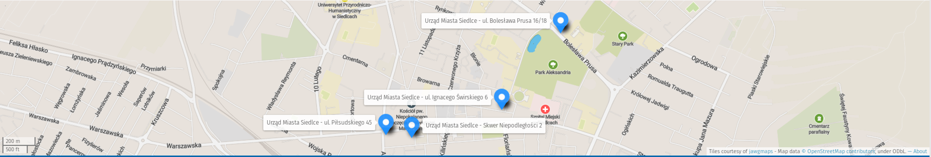
Currently, since 1999, Siedlce is a city with poviat rights in the Mazovia Province.